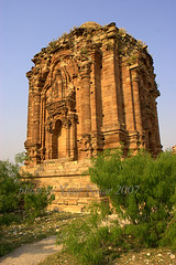
The Malot temples, built of local red sand stones of salt range mountains, are located located on the road leading to Malot village near Choi village. The road is linked with main Kalar kahar road from where it turns from Karuli Chawk towards Malot via Pakistan cement factory and Choi village along with coal mines. It is nine miles away in the south of Katas and same distance from Kalar kahar in the east. It is at the height of 3000 feet and the original spread of the fort was 2000 feet from east to west and 1500 feet from north to south. The inner most spread is 1000 by 500 feet. Gen Cunningham estimated the radius of 2.5 miles.
The Malot was also called Namrod and Ramrod. Gen Abbot has mentioned its name as Shah Garh or Shai Garh but Janjuas name d it Raj Garh. The name is after the King of MalDev or Malu. The Rajput history claims its name Malot from the word Malik-Kot as they believed that the title of Malik was given to the one who accepted annexation to the Muslim King of Delhi although in reward the Malik enjoyed the autonomous status with full sovereignty in the assigned area. The Mughal King Babur’s travelogue “Tuzkai-Babree” attests to the corollary of Malik-Kot, Mal-Kot and then Malot. According to Ghadholak Rajput archives the city of Delhi was built around 994 AD and Malot was built around 980 AD. Gen Cunningham found the Malot Fort and Temples in a very bad shape even in 1848.
The two present temples were looked after by the Brahman Bali Hindus till 1947. The Guru of Bali Hindus, Guru Tarlok Nath shrines were frequently visited by them. In the year 1527 Daulat khan Lodhi was forced by the royal forces of Mughal king Babur, to surrender. Mahan Singh, father of Maharaja Rangeet singh, also built a small fort here at Malot in early 19th century.
The access to Salt Range Mallot Temples Distt Chakwal is as follows,
Coming from Lahore / south-western parts of Pakistan or from Islamabad / Rawalpindi we will travel on motorway till Kallar Kahar interchange. From Kallar Kahar interchange toll plaza we will be taking turn going towards Choa Saidan Shah Distt Chakwal, leaving the other turn going towards “Soon-Sakeisar valley. From there about 2km away there is a right turning called “Karuli chowk” from here the road will lead us to Choi village after passing near by newly established Pakistan Cement Factory. After Choi village we will reach Mallot village where Mallot Temples are located which were built circa 900-1000 years ago. The total distance will be around 35-40 minutes from “Karuli chowk” to Mallot village.
Subscribe to:
Post Comments (Atom)


2 comments:
The text was originally written and contributed by me. It was posted on a couple of websites. But I do not mind posting the same over here verbatim. We must share knowledge as we live in the age of dissemination of knowledge
Shahid Nadeem
taimur66@hotmail.com
The text was originally written and contributed by me. It was posted on a couple of websites. But I do not mind posting the same over here verbatim. We must share knowledge as we live in the age of dissemination of knowledge
Shahid Nadeem
taimur66@hotmail.com
9:41 PM
Post a Comment